| dc.contributor.author | Kyncl, Günter | |
| dc.contributor.author | Lysák, Jakub | |
| dc.contributor.editor | , | |
| dc.date.accessioned | 2025-03-31T11:11:02Z | |
| dc.date.available | 2025-03-31T11:11:02Z | |
| dc.date.issued | 2024 | |
| dc.identifier.uri | https://hdl.handle.net/20.500.14178/3043 | |
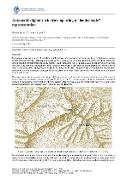
| dc.description.abstract | Topographic maps are a source of very detailed information about the terrain and serve as a basis for fieldwork in manysectors of human activity. Cartographic processing of areas with rock formations is often a rather complicated task dueto their specific characteristics, especially steepness and ruggedness. One of possible ways to depict rocks in the mapvery well, is by hachures. However, the manual creation of hachures is very demanding, both technically and in terms oftime. At the same time, the automatic creation of hachures for the representation of rock formations has not yet beensatisfactorily solved completely, although partial successes have already been achieved recently.This paper deals with automation of drawing rock hachures in the "ladder style", an approach frequently used in maps ofCentral and Eastern European countries. The presented approach is focused on the automatedcreation of cartographic representations of rocks primarily for the purposes of the Czech state map series, while withcertain modifications and necessary data it could be applied elsewhere.The proposed procedure is based on 3 types of input data: polygons representing the ground plan of the rock areas, adigital terrain model (DTM) in the vicinity of the rock formations and selected terrain skeleton lines in the areas of therock formations or their surroundings, derived from generalised DTM. The whole procedure involves several sub-steps.The processing is carried out sequentially along the individual polygons of the rock formations in a following way:- generalization of a DTM, as it is usually too detailed for the purpose of hachuring. To generalize the DTM, theLine Integral Convolution (LIC) method is used, which preserves significant edges during the generalizationprocess.- vertical hachures generation based on the generalized DTM and, eventually, the terrain edges.Vertical hachures follow the steepest gradient of generalized DTM. Starting at highest unprocessed pixel ofDTM in shaded part, or at lowest unprocessed pixel of illuminated part, a hachure is drawn downhill or uphill,until several conditions are met. Pixels of DTM along a successfully created hachure are marked as processed.By repeating, the area of the whole polygon is gradually filled.- horizontal hachures generation. These are made up of contour segments of suitable elevationcreated from the generalized DTM. The contours segments are used only locally to create "rungs of the ladder".- emphasizing ridgelines and upper part of rock, using affine transformation of a predefinedpattern, aligned with vertical hachures.- shading of the vertical and horizontal hachures and representations near the upper edge of the polygon isperformed, using an illumination model derived from generalized DTM.The aim of this paper is to present experimental results of the outlined procedure and its known limits. Although the"ladder-style" portrayal of rocks is not so sophisticated as the "Swiss-style", it is traditionally used in Czech topographicmaps and state map series. The presented algorithm could significantly contribute to the creation of topographic mapsregarding rock formations, or to reduce the amount of manual work required in their creation. | en |
| dc.language.iso | en | |
| dc.publisher | International Cartographic Association | |
| dc.relation.url | https://doi.org/10.5194/ica-abs-7-81-2024 | |
| dc.rights | Creative Commons Uveďte původ 4.0 International | cs |
| dc.rights | Creative Commons Attribution 4.0 International | en |
| dc.title | Automatic digital rock drawing using a "ladder style" representation | en |
| dcterms.accessRights | openAccess | |
| dcterms.license | https://creativecommons.org/licenses/by/4.0/legalcode | |
| dc.date.updated | 2025-03-31T11:11:02Z | |
| dc.subject.keyword | rock hachures | en |
| dc.subject.keyword | digital cartography | en |
| dc.subject.keyword | topographic map | en |
| dc.publisher.publicationPlace | Vídeň | |
| dc.relation.fundingReference | info:eu-repo/grantAgreement/MSM//SVV260694 | |
| dc.relation.fundingReference | info:eu-repo/grantAgreement/UK/GAUK/GAUK87624 | |
| dc.relation.fundingReference | info:eu-repo/grantAgreement/UK/COOP/COOP | |
| dc.date.embargoStartDate | 2025-03-31 | |
| dc.type.obd | 57 | |
| dc.type.version | info:eu-repo/semantics/acceptedVersion | |
| dc.identifier.doi | 10.5194/ica-abs-7-81-2024 | |
| dc.identifier.obd | 655388 | |
| dc.subject.rivPrimary | 10000::10500::10508 | |
| dcterms.isPartOf.name | European Cartographic Conference – EuroCarto 2024 | |
| dcterms.isPartOf.journalYear | 2024 | |
| dcterms.isPartOf.journalVolume | 2024 | |
| dcterms.isPartOf.journalIssue | 7 | |
| dcterms.isPartOf.isbn | 0-000-00000-0 | |
| uk.faculty.primaryId | 115 | |
| uk.faculty.primaryName | Přírodovědecká fakulta | cs |
| uk.faculty.primaryName | Faculty of Science | en |
| uk.department.primaryId | 1058 | |
| uk.department.primaryName | Katedra aplikované geoinformatiky a kartografie | cs |
| uk.department.primaryName | Department of Applied Geoinformatics and Cartography | en |
| uk.event.name | European Cartographic Conference – EuroCarto 2024 | |
| dc.description.pageRange | 1-2 | |
| dc.type.obdHierarchyCs | PŘÍSPĚVEK V KONFERENČNÍM SBORNÍKU::příspěvek v konferenčním sborníku::příspěvek v recenzovaném konferenčním sborníku | cs |
| dc.type.obdHierarchyEn | PAPER IN CONFERENCE PROCEEDINGS::article in proceedings::article in reviewed proceedings | en |
| dc.type.obdHierarchyCode | 57::148::499 | en |
| uk.displayTitle | Automatic digital rock drawing using a "ladder style" representation | en |